
TxDOT's I-14 Implementation Plan Now Guiding Future Planning for Corridor
TxDOT has released the results of their year-long I-14 System in Texas Implementation planning initiative. This is a tremendous step forward on the long road to improving highway travel and safety across the heart of Texas.
You can see and DOWNLOAD A COPY of the planning document here:
https://ftp.dot.state.tx.us/pub/txdot/get-involved/statewide/i-14-system-in-texas/032924-implementation-plan.pdf
 Over the past two decades the I-14 Coalition has worked to lay the groundwork for this milestone. The coalition created the concept of a new east west interstate and a broad corridor that would include interstate connection between key military facilities and important energy production regions to key strategic seaports.
In 2008 we were successful in getting TxDOT to conduct the first feasibility study of the US 190 Corridor across Central Texas which was completed in 2012. In 2015 we were successful in getting Congress to create the Central Texas Corridor generally following the US 190 route and designate it as Future I-14. We celebrated when the first 25 miles of I-14 from I-35 to Killeen was signed in 2017. In 2021 the Coalition was successful in getting Congress to expand the I-14 designation in Texas and eastward across Louisiana, Mississippi, Alabama and Georgia.
Now we have the next step in Texas -- a process and a report that serves as a foundational document to guide TxDOT’s planning, programming and project development activities of this important interstate highway system. TxDOT points out that “the recommendations and associated timeframes for implementation noted in the report are subject to change based on Department priorities, workload, funding, local sensitivities, and other factors.”
We are confident that the work done on the Implementation Plan has created a planning environment that will lead to acceleration of priority incremental highway improvements across the entire I-14 System in Texas – from Odessa to the Sabine River and south to I-10 at Pecos County, Junction and Beaumont.
The I-14 Coalition extends our thanks to Steve Linhart and Lorena Echeverria de Misi of the TxDOT Corridor Planning Branch for their work over the past two years to bring this initial version of the I-14 Implementation Plan to reality.
Interstate 14 Will Serve Local, Regional And Eventually Cross-Country Travel
Years of work by the I-14 Coalition and other supporters of Interstate 14 has paved that way for a future I-14 to serve local, inter-regional and cross-country travel.
Congressional designation of the Interstate 14 Corridor across Texas, Louisiana, Mississippi, Alabama and Georgia became a reality on November 15, 2021, with the presidential signing of the $1.2 trillion Infrastructure Investment and Jobs Act (IIJA), also known as the 2021 bipartisan infrastructure bill.
Most sections of the newly designated I-14 Corridor will be built by incrementally upgrading existing highways in each of the five states.
“Building I-14 along its 1,300 mile path will require billions of dollars and many years to complete but we are on our way,” said John Thompson, former chairman of the I-14 Coalition (Gulf Coast Strategic Highway Coalition) which has been building grassroots support for I-14 over the past two decades.
FUNDING
The IIJA does not include federal funding allocations for projects on any new interstates including the I-14 System. The federal program that funded most of the cost of the national Eisenhower Interstate Highway System ended in the 1990s. In the 21st Century new interstate miles must be funded with a combination of state, local and federal resources. State DOTs make funding decisions on new interstate miles and those projects must compete for funding with other projects in the state for limited available funds.
Over the next few years the 2021 infrastructure bill will provide the states with unprecedented federal transportation funding levels -- an opportunity to jump-start the planning and construction of some priority I-14 route projects most needed to address urgent localized safety and mobility issues.
MOVING FORWARD
The first section of the I-14 Corridor in Texas was approved by Congress in 2015 and the 25 miles of freeway from Killeen/Fort Cavazos (Hood) to I-35 in Central Texas became I-14 in 2017.
The 2021 law expanded the Texas designation to include San Angelo and Midland-Odessa. It also includes four north-south future interstate spurs that will connect I-14 to Interstate 10 and serve the Port of Corpus Christi, the Port of Houston and the ports at Beaumont and Port Arthur. It also adds a fifth north-south spur connecting to the Port of Gulfport in Mississippi. Plus the designation includes a future interstate loop at Bryan-College Station designated Interstate 214.
Congressman Brian Babin of Woodville, Texas, has been carrying the I-14 legislation since entering Congress in 2015. The latest version of the legislation was successfully included in a House transportation bill passed early in 2021. It became the basis of an amendment to the bipartisan IIJA offered successfully in August by Sen. Ted Cruz of Texas and Sen. Raphael Warnock of Georgia. The I-14 designation had the support of all 10 senators and every member of the House along the corridor. The Texas, Louisiana, Mississippi, Alabama and Georgia state departments of transportation (DOTs) and 14 metropolitan planning organizations (MPOs) all provided letters to Congress supporting the new interstate corridor. The Gulf Coast Strategic Highway Coalition worked closely during this successful effort with the Youth Infrastructure Coalition which successfully built community support for the I-14 designation across Georgia and Alabama.
In the years ahead elected officials and community leaders along the I-14 Corridor must work to win funding for planning and construction of projects on the corridor, work that must be done with Congress, the U.S. Department of Transportation and in each state with the state legislature and the state DOT decision-makers.
 The I-14 Central Texas Corridor was authorized in 2015 generally following US 190. The first 25-mile section of I-14 from Killeen and Fort Cavazos to I-35 at Belton was added to the Interstate Highway System in 2017.
It also authorizes the new interstate route using the general pattern of existing roads and highways, but leaves the final determination about the exact path of the route with state officials and local communities.
The I-14 Gulf Coast Strategic Highway Coalition has supported incremental improvements to highways in the corridor for two decades. Coalition Chairman John Thompson, former County Judge of Polk County, TX, notes that the expanded I-14 corridor will provide greater efficiency in the movement of freight in each of the five states and nationally.

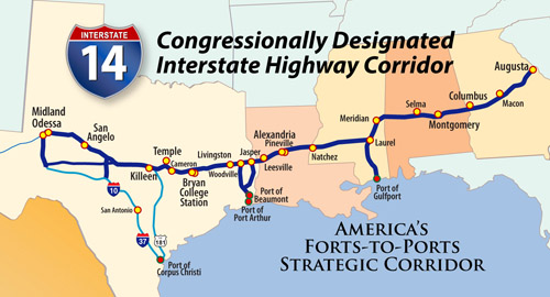
The map above reflects the provisions of federal legislation passed by Congress that expanded the I-14 Central Texas Corridor across Gulf Coast states and Georgia in 2021. It also includes the new names of five of the military installations served by the I-14 Corridor. All earlier Coalition maps are no longer accurate. [You can Download a hi-res PDF of this June 2023 graphic HERE]
ENHANCING MILITARY VALUE OF DOD FACILITIES
A significant benefit of providing interstate linkage between a dozen military facilities served by the I-14 Corridor is that these connections will add to the military value of each of these installations. And military value is a key to preserving and growing Army and Air Force facilities.
Among the facilities that will be better linked by I-14 are Fort Bliss at El Paso, Goodfellow AFB in San Angelo, Fort Cavazos (Hood) at Killeen, Fort Johnson (Polk), England Air Park and Camp Beauregard in Louisiana, Camp Shelby at Hattiesburg, Kessler AFB at Biloxi, Maxwell AFB and Fort Novosel (Rucker) in Alabama, Fort Moore (Benning) at Columbus, Robins AFB at Macon, Fort Eisenhower (Gordon) near Augusta and Fort Stewart near Savannah.
The I-14/Gulf Coast Strategic Highway System concept was originally developed with a focus on better connecting Fort Johnson, Fort Cavazos and Fort Bliss to the designated Strategic Military Deployment Ports on the Texas Coast.
Since the early 2000s a generation of military base commanders and their community supporters have stressed that I-14 and its coastal connectors will provide invaluable redundant capability to move military equipment to and from strategic deployment ports. They make it clear that mobility and connectivity improvements create military value essential to base viability.
I-14 Central Texas Route Study Underway
January 2022
Efforts by the I-14 Coalition to urge action on the I-14 development process in Texas took a big step forward in 2020 when the Texas Department of Transportation began a program that will lead to selection of a preferred route for I-14 across Central Texas.
A consultant team led by Reynolds, Smith & Hills went to work in 2021. They will collect extensive data, conduct detailed studies, develop preliminary designs, collect public input and assist with selection of a route connecting I-35 and I-45 and serving Bryan-College Station.
While the I-14 congressional designation identifies the corridor as generally following US 190, the new route is not expected to follow a significant portion of the zig-zag path of the current US 190 highway across the Brazos Valley region.
The feasibility study area starts on US 190 near Rogers and extends eastward crossing the Little River, the Brazos River and the Navasota River. The east terminus is a point on US 190 about 14 miles east of Huntsville in Walker County, a total of about 115 miles.
The consultants are collecting geographic, environmental and traffic information. There will be meetings with stakeholders and members of the community starting in the first half of 2022. The public engagement process is expected to continue over several years as potential routing options are identified and evaluated.
A study completed in 2018 recommended that I-14 run on I-35 from its current terminus in Belton to US 190 in Temple and then follow the path of US 190 to near the town of Rogers. Upgrade projects are in development or have been completed in the section from Temple to Rogers.
The TxDOT Bryan District is overseeing the feasibility and route studies. The goal is to make a selection that will enhance east-west connectivity, improve safety and relieve congestion while minimizing environmental impact.

New Law Designates Five
High
Priority Corridors As Interstate 14
January, 2022
The I-14 congressional designation that became law in the Infrastructure Investment and Jobs Act of 2021 (IIJA) creates four new High Priority Corridors and expands the existing I-14 Corridor in Texas. Each corridor has a number, as shown. Here is a summary of the I-14 statute route description language:
CENTRAL TEXAS CORRIDOR (84)
The statute designates a future I-14 North and a future I-14 South in West Texas. I-14 North begins at Odessa, generally following I-20 and connecting to SH 158 in Midland. It follows SH 158 to US 87 and then follows US 87 passing in the vicinity of San Angelo then east to Eden and Brady. I-14 South begins in Pecos County and follows US 190 east to Menard and Brady. From Brady the corridor generally follows US 190 passing in the vicinity of Fort Hood, Killeen, Temple, Bryan, College Station, Huntsville, Livingston, Woodville and Jasper. From Jasper it follows SH 63 to the Sabine River Bridge.
The corridor also includes four spur routes: From Odessa south to I-10 generally following US 385 and SH 305; from Eden south to I-10 at Junction generally following US 83; from Woodville south to I-10 at Beaumont following US 69; and from Jasper south the I-10 following US 96. The IIJA designates a future interstate loop at Bryan-College Station as I-214. The IIJA directs that the north-south spur routes in Texas and Mississippi shall be given separate Interstate route numbers when completed.
CENTRAL LOUISIANA CORRIDOR (99)
This section of Future I-14 begins at the logical terminus of LA Highway 8 at the Sabine River Bridge at Burrs Crossing. It follows LA 8 to Leesville and Fort Polk, and then runs eastward generally following LA Highway 28, passing in the vicinity of Alexandria, Pineville, Walters, and Archie, then follows US 84 to the Mississippi River at Vidalia. It crosses through Vernon, Rapides, La Salle, Catahoula and Concordia Parishes.
CENTRAL MISSISSIPPI CORRIDOR (100)
This section begins at the Mississippi River in the vicinity of Natchez and generally follows US 84 eastward to I-59 at Laurel. It then runs north concurrently with I-59 to I-20 at Meridian and east on I-20 to the Alabama state border. The corridor also includes a spur following I-59 south to Hattiesburg and then US 98 and US 49 south to Gulfport.
MIDDLE ALABAMA CORRIDOR (101)
From the Mississippi state border this section concurrently follows I-20 then generally follows US 80 eastward passing near Selma and then to I-65 near Hope Hull. It then runs along the proposed Montgomery Outer Loop and continues east concurrently on I-85 to Opelika OR follow US 80 to Tuskegee. It then follows the most expedient route to join US 80 terminating at Phenix City.
MIDDLE GEORGIA CORRIDOR (102)
From the Alabama state border at the Chattahoochee River this section generally follows the Fall Line Freeway from Columbus to Augusta. Specifically it follows US 80 through Columbus and east to Geneva where it follows Georgia Routes 96, 49C and 49 then runs concurrently with I-75 and I-16 through Warner Robins and Macon. It then generally follows US 80 and US 57 before joining State Route 24 to near Wrens, then follows US 1 to the final terminus at I-520 in Augusta.
Telling the Story in Mississippi
October 2019
Many of those participating in the Southwest Mississippi Partnership’s Balloon Festival Symposium in October 2019 knew little about the I-14 initiative and the possible economic development I-14 will help foster in that state. Coalition Chairman John Thompson made a presentation outlining the long history of the I-14 advocacy effort, the importance of linking US military facilities, and progress made in Texas.
He was one of three speakers during the session that included remarks by Lt. Gov. Tate Reeves and Attorney General Jim Hood. Both offered their support for future highway improvements.
Coalition Celebrates First Sign on New I-14

April 25, 2017
KILLEEN, TEXAS – Community representatives from along the Interstate 14 route across Texas gathered in Killeen on April 22 to celebrate the unveiling of the first signs on the nation’s newest interstate highway.
The first 25-mile segment of US 190 is now part of the Interstate Highway System. It runs from Interstate 35 in Belton to Copperas Cove and provides direct access to the main gate at Fort Hood in Killeen.
 John Thompson, former county judge of Polk County and founding chairman of the Gulf Coast Strategic Highway Coalition, said the celebration marked a momentous occasion for Texas, for Fort Hood and for Bell County. He noted that it was appropriate for the first I-14 section to be in Killeen because Killeen is a charter member of the Coalition along with several East Texas communities and the Port of Corpus Christi Authority.
“There are challenges to getting across Texas between I-10 and I-20 and we have brought a solution to the table,” Thompson said. He explained that a key moment came in 2002 when the Coalition developed the “Forts-to-Ports” concept of an improved strategic highway system.
“It was at that point that we realized how important this highway was, not just to economic purposes, but to our country, to the world and certainly to those folks along that route. The strategic highway as now envisioned will link Fort Bliss, Fort Hood and Fort Polk with their deployment ports. And as I talk to the various folks at the forts around the country I hear that one of the big factors, the heavily weighted factor is how quickly they can deploy. And this interstate system will take movements from our forts to either Corpus Christi or Beaumont, both strategic military deployment ports. It is so important. Plus, the extra benefit is what we gain from the economic value along the route,” Thompson said.
Col. Todd Fox, Fort Hood (now Fort Cavazos) garrison commander, speaking during the ceremony said, “The designation of US 190 as Interstate Highway 14 is a tremendous achievement and would not have been possible without incredible teamwork and support from our local communities.” He said that the transportation flexibility provided by the improving highway system adds significant military value to the sprawling Fort Hood complex.
U.S. Senators John Cornyn and Ted Cruz spoke to the celebration participants via video.
“The I-14 corridor is an example for the rest of the country and I am proud that Texas is leading the way,” Sen. Cornyn said. “Not only will this designation help our military transfer essential good, but it will also help families and economies across America. This 25-mile stretch is only the beginning. Keep up the great work.”
Sen. Cruz thanked Gulf Coast Strategic Highway Coalition members for their tireless dedication to making I-14 a reality. He called the signing of the first section an exciting and important development for Central Texas communities. “It not only offers residents an easier commute but enhances the power projection capability of Fort Hood as the Army works to move their ground assets to the ports for movement to a theater for deterrence and, if needed, combat operations. This is an exciting time for the state of Texas,” he said.
In 2015, the Congress created the Central Texas Corridor generally along the US 190 route and designated it as future I-14. The Coalition and members of Congress are currently supporting additional legislation to adjust the corridor in West Texas so that it will serve San Angelo and Midland-Odessa. Thompson noted that Congressman Brian Babin of Woodville and Sen. Cornyn were the authors of the 2015 legislation and that Babin is leading the effort in Congress to expand the I-14 corridor.
Also speaking at the celebration were Congressman John Carter who represents Killeen and the Fort Hood headquarters and Congressman Roger Williams who represents Coryell County and much of the northern portion of Fort Hood.
Carter called the Forts-to-Ports concept behind I-14 and the associated strategic highways “critical to freedom around the world.” He encouraged supporters to keep dreaming and making their dreams happen.
Williams, who first proposed the I-14 designation when he served on the U.S. House Transportation Committee, said the addition of the 25 miles of freeway to the interstate system shows the nation’s commitment to our military and to their families.
Marc Williams, deputy executive director of the Texas Department of Transportation, pointed out that I-14 now connects Fort Hood to the 50-year-old Eisenhower System of Interstate and Defense Highways. “We are about 25 years overdue in making this connection,” he said. He noted that it had been a team effort involving many stakeholders and political leaders with the final approval action to designate it as an interstate being approved earlier this year by the five members of the Texas Transportation Commission.
The congressionally designated Central Texas Corridor begins in West Texas and runs through Killeen, Bryan/College Station, Huntsville, Livingston, the Alabama-Coushatta Tribe Reservation, Woodville and Jasper before crossing into Louisiana at the Sabine River near Fort Polk. Thompson said upgrading this corridor to interstate standard will mean improved safety and traffic mobility.

Celebration program participants (l-r) Bobby Littlefield, retired TxDOT Waco District Engineer; Marc Williams, TxDOT Deputy Executive Director; State Representative Hugh Shine of Temple; State Senator Dawn Buckingham; Congressman John Carter; Congressman Roger Williams; State Representative Scott Cosper of Killeen; Army Col. Todd Fox of Fort Hood; and Judge John Thompson, chairman of the Gulf Coast Strategic Highway Coalition. [FULL PHOTO GALLERY HERE]
Momentum Building for New Interstate 14
February, 2017
AUSTIN, TEXAS – While development of Interstate 14 across Texas will take decades, momentum for improvement projects in the corridor is building and has support from the Texas Department of Transportation (TxDOT).
Representatives of two dozen communities that make up the Gulf Coast Strategic Highway Coalition gathered in Austin this week to hear about current and future highway transportation needs including the fact that improved highways add military value to bases in Texas and Louisiana.
The first 25-mile segment of US 190 is now part of the Interstate Highway System. It runs from Interstate 35 in Belton to Copperas Cove and provides direct access to the main gate at Fort Hood in Killeen. A celebration is being planned in the coming months to unveil the first I-14 signs.
 For more than a decade the Gulf Coast Strategic Highway Coalition has been advocating for improved highway connections between U.S. Army facilities at Fort Hood, Fort Bliss and Fort Polk and the strategic military deployment ports at Beaumont and Corpus Christi. Such improvements increase the military value of those installations as they perform their assigned mission.
“Since the Interstate Highway System was designated initially as a defense highway system, it only makes sense that with a military installation like Fort Hood we would want to make sure that it is tied and connected directly to our interstate system,” TxDOT Deputy Executive Director Marc Williams told the group during the Coalition’s annual meeting.
In 2015 the Congress created the Central Texas Corridor generally along the US 190 route and designated it as future I-14. The Coalition and members of Congress are currently supporting additional legislation to adjust the corridor in West Texas so that it will serve San Angelo and Midland-Odessa.
Williams noted that it took only a year to go from congressional action to final decision on the first segment of I-14. He warned that it is going to take a long time and concerted effort to continue the progress. “The important thing is that you all have some momentum, you are organized, you are promoting the importance of that corridor, and TxDOT wants to do our part as well. We are working within our Transportation Planning and Programming Division to understand and begin to look at the feasibility of incremental improvements to that corridor,” Williams said.
He noted that the Texas Transportation Commission includes members who are strong supporters of highway projects that provide connectivity between regions and centers of commerce and production. He said Commission Chairman Tryon Lewis of Odessa certainly appreciates the significance of making investments to ensure that all of Texas is connected to key transportation corridors.
In a video message sent to the group, Congressman Brian Babin of East Texas said he believes I-14 can be an example to the nation of Congress getting something right when it comes to transportation. Congressman Babin is a member of the U.S. House Transportation Committee and was the House sponsor of the I-14 designation language. Senator John Cornyn sponsored the effort in the U.S. Senate.
Speakers during the annual meeting stressed the need for improved connectivity, particularly between the key Permian Basin oil and gas production region and seaports on the Texas Coast.
That included James Beauchamp, president of the Midland-Odessa Transportation Alliance, who explained that the Permian Basin is responsible for more than 50% of the oil produced in Texas and that the Texas Railroad Commission estimates there are roughly 500 years of recoverable oil and gas resources in the region.
“Our region is growing but we are isolated. That is why these highway connections are so important to us,” he said. He pointed to the value of improved highway connections between the Permian Basin and the frac sand mines in McCulloch County and the oil refineries and export terminals at the Port of Corpus Christi.
Roland Pena, economic development director for the City of San Angelo, also pointed to long-term energy development in West Texas and the importance of transportation in serving energy industry growth.
The Coalition also heard updates on transportation needs from Charlie Zahn, chairman of the Port of Corpus Christi Authority, Clayton Henderson of the Port of Beaumont, Major Gen. Kendall Cox who heads the Heart of Texas Defense Alliance, Malcolm Morris who represents communities supporting Fort Polk in Louisiana, McCulloch County Judge Danny Neal who talked about the expansion of frac sand mines in his county and Jasper County Judge Mark Allen who talked about the need for improvements in East Texas.
John Thompson, former county judge of Polk County and board chairman of the Gulf Coast Strategic Highway Coalition, said these updates helped Coalition members better understand how improvements to the I-14 Corridor and its connector spurs will help Texas take advantage of energy industry growth and provide new economic development opportunities across a wide area of the state.
The Central Texas Corridor begins in West Texas and runs through Killeen, Bryan/College Station, Huntsville, Livingston, the Alabama-Coushatta Tribe Reservation, Woodville and Jasper before crossing into Louisiana at the Sabine River near Fort Polk. Thompson said upgrading this corridor to interstate standard will mean improved safety and traffic mobility while creating new growth opportunities for the communities in the regions served by the future interstate highway.
Central Texas Freeway Now Interstate 14;TxDOT Commission Gives Final Approval
January, 2017
AUSTIN, TEXAS – The Texas Transportation Commission voted Thursday to give final approval to designation of 25 miles of US 190 freeway in Bell County as Interstate 14.
The freeway segment is now part of the Interstate Highway System and Interstate 14 signs will go up in the coming months on the section stretching west from Interstate 35 in Belton to the eastern edge of Copperas Cove.
The Texas Department of Transportation’s Waco District spent the past year working with the Federal Highway Administration to review elements of the existing highway to confirm they meet required interstate highway design standards. Highway upgrades of this segment have been underway for the past few years and more expansion projects are planned.
Leading up to the final decision, the I-14 designation was previously approved by the Killeen-Temple Metropolitan Planning Organization, the American Association of State Highway and Transportation Officials, and the Federal Highway Administration.
John Thompson, former county judge of Polk County and board chairman of the Gulf Coast Strategic Highway Coalition, had high praise for the Transportation Commission’s swift action in making the first section of Interstate 14 a reality. He noted it took only a year to reach that milestone following the congressional designation of the Central Texas Corridor as future I-14 as part of the FAST Act in December 2015.
I-14/US 190 serves as the primary access to Fort Hood at Killeen, home of 36,000 military personnel and 50,000 family members. Fort Hood is the largest single site employer in Texas.
John Crutchfield, president of the Killeen Chamber of Commerce, said I-14 is more than a highway project, it is a way for the state to support one of the most important military facilities in the nation.
Major General Ken Cox USA (ret), president of the Heart of Texas Defense Alliance, noted that the 25-mile highway segment was recently used by the Army to deploy Army units to Europe.
The Central Texas Corridor begins in West Texas and runs through Killeen, Bryan/College Station, Huntsville, Livingston, Woodville and Jasper before crossing into Louisiana at the Sabine River near Fort Polk. Thompson said upgrading this corridor to interstate standard will mean improved safety and traffic mobility while creating new economic development opportunities for the communities in the regions served by the interstate highway.